CED draws a wide membership of interested people from many disciplines. Marga has kindly provided this article she authored on ancient communities and landscapes. It is something a little different to our usual NewsFlash but we hope you find it interesting.
Marga Jann, AIA, RIBA, DPUC
American University of Kurdistan (AUK) / Cambridge University
A tell is an artificial hill created by many generations of people living and rebuilding on the same spot. Over time, the level rises, forming a mound. The single biggest contributor to the mass of a tell are mud bricks, which disintegrate rapidly. Excavating a tell can reveal buried structures such as government or military buildings, religious shrines, and homes, located at different depths depending on their date of use. They often overlap horizontally, vertically, or both. [1] Archaeologists excavate tell sites to interpret architecture, purpose, and date of occupation.
In archaeology, a tell, or tel (derived from Arabic: لَت ,tall, ‘hill’ or ‘mound’), is an artificial mound formed from the accumulated refuse of people living on the same site for hundreds or thousands of years. A classic tell looks like a low, truncated cone with sloping sides and can be up to 30 metres high.
Tells are most commonly associated with the archaeology of the ancient Near East, but they are also found elsewhere, such as Central Asia, Eastern Europe, West Africa and Greece. Within the Near East, they are concentrated in less arid regions, including Upper Mesopotamia, the Southern Levant, Anatolia and Iran. [2]
The Kurdish tell, which gracefully and abundantly peppers the landscape in and around Duhok where I have been teaching architectural engineering these past two years, is a huge, tapered man-made mound (or berm) enveloping debris, archaeological remains, or garbage. As such it serves as a valuable model for recycling refuse via sustainable landscaping and treating waste through recovered, camouflaged landfill piles (resourceful adaptive reuse). The archaeological stratification of many of these tells further reveals architectural ruins, foundations, and multiple mud-brick layers shedding remarkable light on ancient (and more modern) history and settlements–constituting crucially significant 3D archives–far more revealing than imaginative, green ‘garbage dumps’ or landfill knolls.
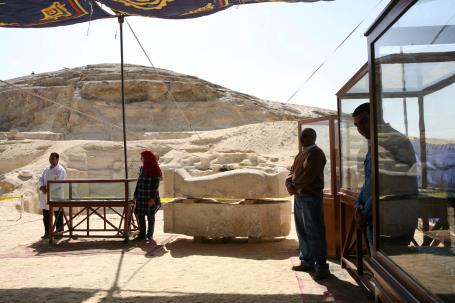
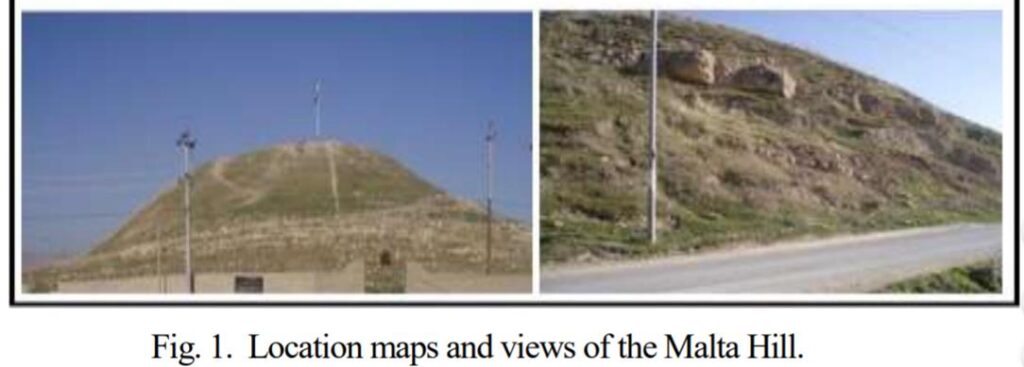
Contemporary, sanitary disposal/landfill fields typically layer waste in a large pit, sometimes up to 500 feet into the ground, such as Puente Hills, outside Los Angeles. [3] Landfills can also be ‘carefully designed structure(s) built into or on top of the ground in which trash is isolated from the surrounding environment (groundwater, air, rain).’ [4] Eventually trash becomes archeological remnant (e.g. organic residue in earthen vessels) from which a plethora of information about man’s past and development can be gleaned. Some tells even contain bones or serve as cemeteries, such as the Malta Tell in Duhok or the Tell el-Amarna / El Minya’s recently discovered City of the Dead (Upper Egypt), shown below.
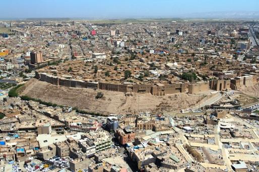
While tells can also consist of the ‘remains of a city or village, built and rebuilt in the same location for hundreds or thousands of years’ [5] and can ‘range in diameter from 30 meters (100 feet) to 1 kilometer (.6 mile) and in height from 1 m (3.5 ft) to more than 43 m (140 ft)’, [6] of which Erbil’s Citadel is an outstanding example, they are typically non-commemorative. Rather than excavating these sites or tells (e.g. Erbil’s Citadel) via archaeological digging, which is now considered destructive, techniques like remote sensing, underground radar and magnetic imaging, and thermal imaging employing aerial drones can be used (e.g. Stonehenge Riverside Project). ‘By outfitting these unmanned craft with thermal cameras, archaeologists have discovered a new and affordable way of seeing what’s underground while flying high above it.’ [7]
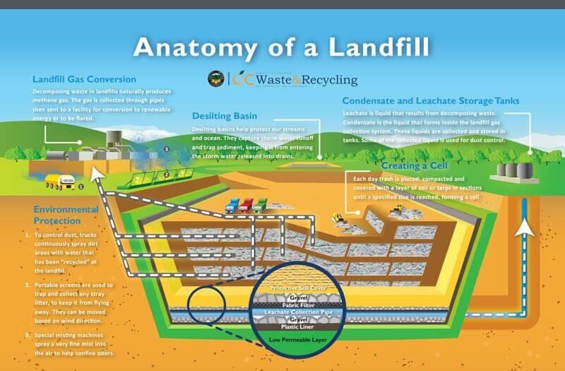
Regarding the tell’s potential as a transferable model for treating waste, it should be noted that refuse decomposes faster when water is added. ‘Normally, plastic items take up to 1000 years to decompose in landfills….Plastic bags we use in our everyday life take 10-20 years to decompose, while plastic bottles take 450 years;’ [8] But ‘trash in a municipal landfill….decomposes nearly 10 to 20 times faster than it normally does through a system that keeps the trash continuously wet.’ [9] So wastewater treatment, as in the diagram on page 3, needs to be an intrinsic part of any ‘sanitary’ landfill, as water will collect from rain and snow, waste producing liquid as it decomposes, and leachate, in any case.
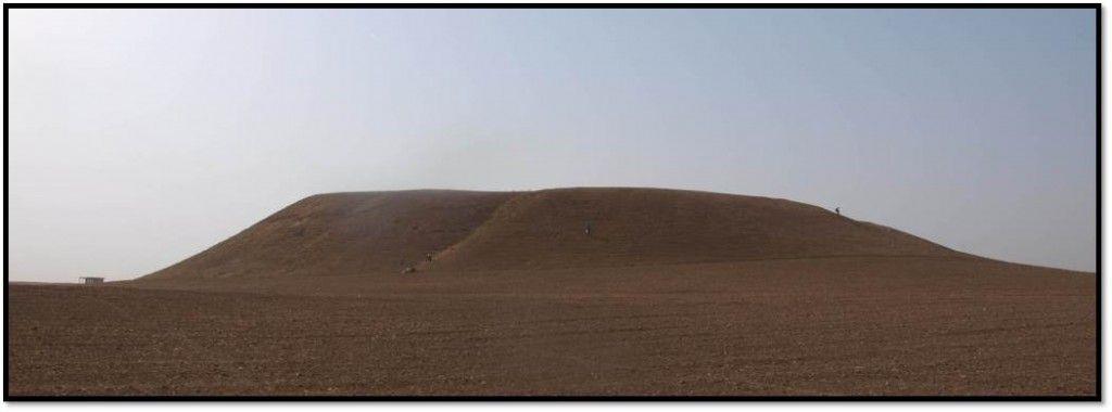
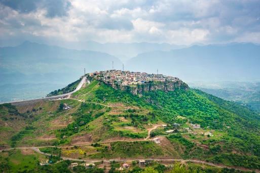
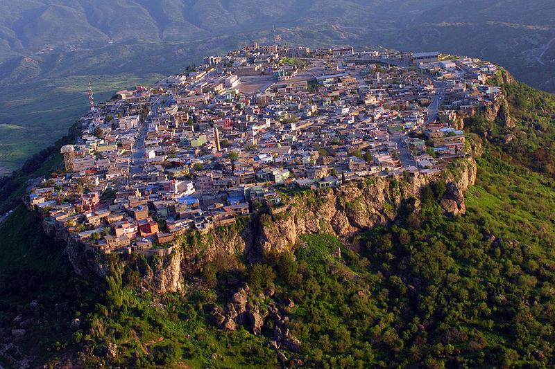
From an archeological/architectural engineering point of view, it is of heuristic value to explore and compare three Iraqi Kurdish tells: the afore-mentioned Erbil Citadel, dating from 5000 BC, the Malta Tell, an old Duhok cemetery and ancient buried stone complex, and Amedi, a historic Assyrian city lodged on a high plateau—not usually considered a tell but situated on a small crater constituting a ‘limestone bed belonging to the Pilaspi limestone formation of Eocene age,’ [10] with the mound’s primary purpose serving as fortification. It is generally held that Amedi is the home of the Bible’s ‘three wise men’ or magi. Unfortunately much of Amedi’s original architecture has been lost, but it is my hypothesis that further archaeological investigation, like that of the Malta site (below), would reveal intricate subterranean foundational structures and layering.
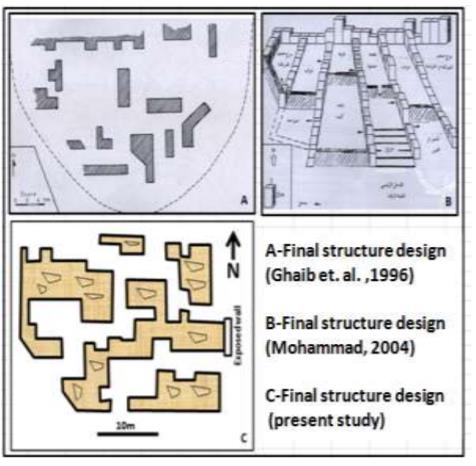
A comprehensive study of the ‘Archaeological Hill Malta at Duhok City’ by Ghaib and Gardi in 2015 [11] develops a model of the subsurface using two geophysical methods (gravity and resistivity) revealing ‘the presence of wall remains distributed in a systematic manner under the surface.’ [12] A more recent cemetery climbs the lower eastern slope. See photos and (conflicting) reconstructed underground structural studies from the Ghaib & Gardi article below:
Returning to the Amedi site (photo below), 90 km northeast of Duhok and founded well over 2000 years ago, many archaeological studies, [13] such as that by Nováček and Amin included in Harvard’s Archaeological Projects in the Kurdistan Region in Iraq (page 6), [14] in conjunction with the Directorate of Antiquities of Kurdistan, reveal little about Amedi’s subsurface or substructure. In that the city fortress or citadel is assumed to have been built originally on a crater, it is probable that the interior of the mound has depth, tunnels, foundations and debris worth exploring (similar to the Erbil Citadel). As an ‘organically evolved (fossilized) landscape,’ [15] Amedi is a remarkable example of man adapting natural terrain to both serve and contain his shelter/security needs–unlike our borderless, contemporary urban development and sprawl.
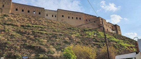
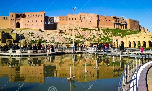
The extraordinary UNESCO World Heritage Erbil Citadel (Qelat in Kurdish), which predates the Pyramids, has been well documented and studied. Archaeological digs reveal centuries of layers of built form. The ‘settlement mound – of roughly oval shape…is between 25 and 32 metres (82 and 105 ft) high. The area on top of the mound measures 430 by 340 metres (1,410 ft × 1,120 ft) and is 102,000 square metres (1,100,000 sq ft) large. Natural soil has been found at a depth of 36 metres (118 ft) below the present surface of the mound. The angle of the citadel mound’s slopes is c. 45°. Three ramps, located on the northern, eastern and southern slopes of the mound, lead up to gates in the outer ring of houses.’ [16] While it is not the purpose of this paper to expound historical merits, these above three examples reveal vernacular design models/precedents which can inform identity, increase self-esteem, and serve to improve the environment both near and far in imaginative and sustainable ways.
As Iraqi Kurdistan seeks to establish distinctiveness, its indigenous landscape, built form, and history offer rich cultural language upon which to build–providing transportable models which can serve other cultures and regions around the globe. In many ways, this ‘hidden country’ is too well kept a secret.